










Seedance 2.5 FPV Drone Video: Create a High-Speed Shanghai Fly-Through
Learn how to use a marked Shanghai route image and structured Seedance 2.5 prompt to create a fast, continuous first-person FPV drone fly-through.
To create an AI city fly-through with a clear route, a prompt needs more than words such as “cinematic” and “high-speed.” The route should be written as a sequence of camera actions the model can follow. In this example, a Shanghai skyline image with a marked flight path is used in Seedance 2.5 to generate a 15-second first-person FPV drone video. The camera starts near the Huangpu River, climbs around the Oriental Pearl Tower, weaves through Lujiazui’s skyscrapers, and accelerates toward the open Pudong skyline.
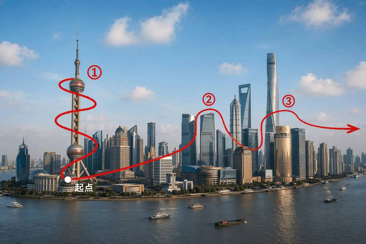
The marked route defines the starting point, landmark order, changes in altitude, and final flight direction.
What You Need for This Seedance 2.5 FPV Drone Video
Prepare the following inputs:
- A clear cityscape reference image with recognizable landmarks.
- A marked starting point, main flight path, and exit direction.
- A prompt that describes the camera route in chronological order.
- Basic visual constraints such as first-person FPV, extreme speed, cinematic motion, and a continuous one-take shot.
The route markings are spatial instructions, not elements that should appear in the generated video. State explicitly that the red line, numbers, arrow, and starting-point label must not be visible in the final result.
Step 1: Break the Flight Path into Continuous Camera Actions
The route in this example can be divided into four connected movements:
- Low-altitude launch: Start near the Huangpu River or the base of the Oriental Pearl Tower to establish a fast, water-level first-person view.
- Orbit and climb: Rise around the tower, passing its shaft, lower sphere, upper sphere, and antenna. This keeps the landmark as the visual anchor for the first half of the shot.
- Skyscraper fly-through: Cross toward the financial district, then add lateral weaving and vertical movement between Shanghai Tower, Shanghai World Financial Center, and Jin Mao Tower.
- Open-skyline exit: Leave the dense cluster of towers and accelerate toward the front-right side of the Pudong skyline, ending on a wide city view.
This structure gives Seedance 2.5 a clear order to follow. It also reduces the risk of the video completing the tower orbit but omitting the later skyscraper sequence.
Step 2: Upload the Route Image and Enter the FPV Prompt
Open WeShop Seedance 2.5 and add the marked Shanghai skyline image as the visual reference. The image below shows the reference already uploaded before the prompt is entered.

The route image is ready in the generation interface; the next action is to enter the motion prompt.
Use this prompt:
Generate a 15-second, first-person FPV video of an ultra-high-speed drone fly-through in a cinematic, continuous one-take shot. Start at low altitude above the Huangpu River, near the base of the Oriental Pearl Tower. Rapidly climb while smoothly orbiting the tower shaft, lower sphere, upper sphere, and antenna. Then follow the spatial relationship indicated by the red route in the reference image, flying at high speed toward the Lujiazui financial district. Weave left and right with rising and diving movement between Shanghai Tower, Shanghai World Financial Center (SWFC), and Jin Mao Tower. Finally, continue in the direction of the arrow and accelerate toward the front-right side of the Pudong skyline, ending on a wide, open city view. Do not show the red route, numbers, arrow, starting-point label, or any other guide markings in the generated video; they are only spatial references.
The prompt follows a practical order:
- Define the duration, perspective, speed, and continuous-shot requirement first.
- Establish an exact starting location.
- Pair every landmark with a specific camera movement.
- Set the exit direction and final composition.
- Explicitly exclude all route annotations from the generated frame.
Step 3: Generate and Check the Complete Flight Route
Generate the video, then review it against the planned route instead of judging it only by how dramatic it looks. Check whether:
- The opening establishes low-altitude speed near the river.
- The camera approaches the Oriental Pearl Tower and performs a clear climbing orbit.
- The motion transitions naturally from the tower toward Lujiazui.
- The camera changes direction and altitude around the three major skyscrapers.
- The ending leaves the dense buildings and opens onto a wider skyline.
- The red line, numbers, arrow, and starting-point label are absent.
In this result, the camera begins above the water and rapidly approaches the Oriental Pearl Tower. It then banks steeply and climbs close to the tower before turning toward the Lujiazui cluster. The later section changes direction around the skyscrapers and finishes by moving away from the dense buildings into a broader city view. The result preserves the core first-person speed and continuous-flight concept.
Final 15-second AI-generated fly-through based on the marked Shanghai route image and structured motion prompt.
You can try it directly using the tool on the right.
Turn the Route into the Shot’s Backbone
The goal is not to reproduce a static skyline image. It is to translate the image’s spatial relationships into continuous motion: the Oriental Pearl Tower creates the orbit and climb, the Lujiazui towers create the high-speed weaving, and the open skyline gives the final acceleration room to resolve.
Draw a similarly simple route around the landmarks in another city, then use WeShop Seedance 2.5 to turn that route into a complete FPV city fly-through.